|
Using autonomous drones to survey penguin colonies 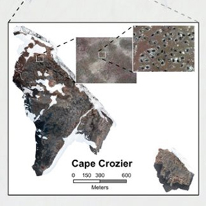
National Science Foundation Posted November 4, 2020 How do you survey thousands of penguins in a matter of hours? Researchers at Stanford University and Point Blue Conservation Science created a new multi-drone imaging system that uses an algorithm for conducting aerial surveys over large penguin colonies. Previous drone surveys at Cape Crozier, one of the largest Adélie penguin colonies in the world, would take up to two days. Using the new system, surveys were completed in less than three hours, making incredible use of limited flight time. This new research has been published in Science Robotics https://bit.ly/326TdeK. The Stanford team also has other plans for its multi-drone system such as monitoring traffic and wildfires. To learn more watch this video https://www.youtube.com/watch?v=w4d7MPYgNA4&feature=emb_logo
|

For USAP Participants |
For The Public |
For Researchers and EducatorsContact UsU.S. National Science FoundationOffice of Polar Programs Geosciences Directorate 2415 Eisenhower Avenue, Suite W7100 Alexandria, VA 22314 Sign up for the NSF Office of Polar Programs newsletter and events. Feedback Form |
